These instruments sit at the surface of the ocean and are transported via near-surface ocean currents. They are not fixed to the ocean bottom, therefore they “drift” with the currents. For this reason, these instruments are referred to as drifters, or drifting buoys.
The surface float contains sensors that measure different parameters, such as sea surface temperature, barometric pressure, salinity, wave height, etc. Data collected from these sensors are transmitted to satellites passing overhead, which are then relayed to land-based data centers.
All drifters measure sea surface temperature and location; the locations are used to calculate ocean current velocities. Additional sensors can be added such as barometric pressure, salinity, wave height, wind speed and direction, optical sensors, and internal surface float diagnostic sensors. Each measurement requires an additional sensor, while wave height measurements also require the absence of a drogue.
A barometer on the top of the float is used to measure sea level barometric pressure. These measurements have been shown to significantly improve weather forecasts.
Sea surface temperature is measured by a thermistor (thermometer) on the bottom of the float.
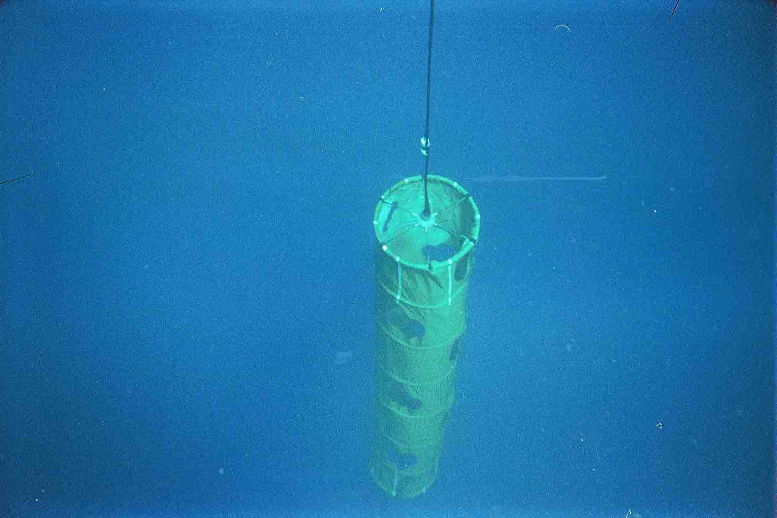
Sea surface current velocities are calculated by the change in position of the drifter over time. The surface float of the drifter is attached to a large holey-sock drogue (also known as a sea anchor) which comprises most of the area of the instrument. The drogue is centered at a depth of 15 meters.
A salinity sensor (specifically, a highly accurate pair of conductivity and temperature sensors) is used to measure sea surface salinity at the base of the surface float. This can also be done deeper on the tether between the float and the drogue.
A sonic anemometer and a wind vane are used to measure wind speed and wind direction.
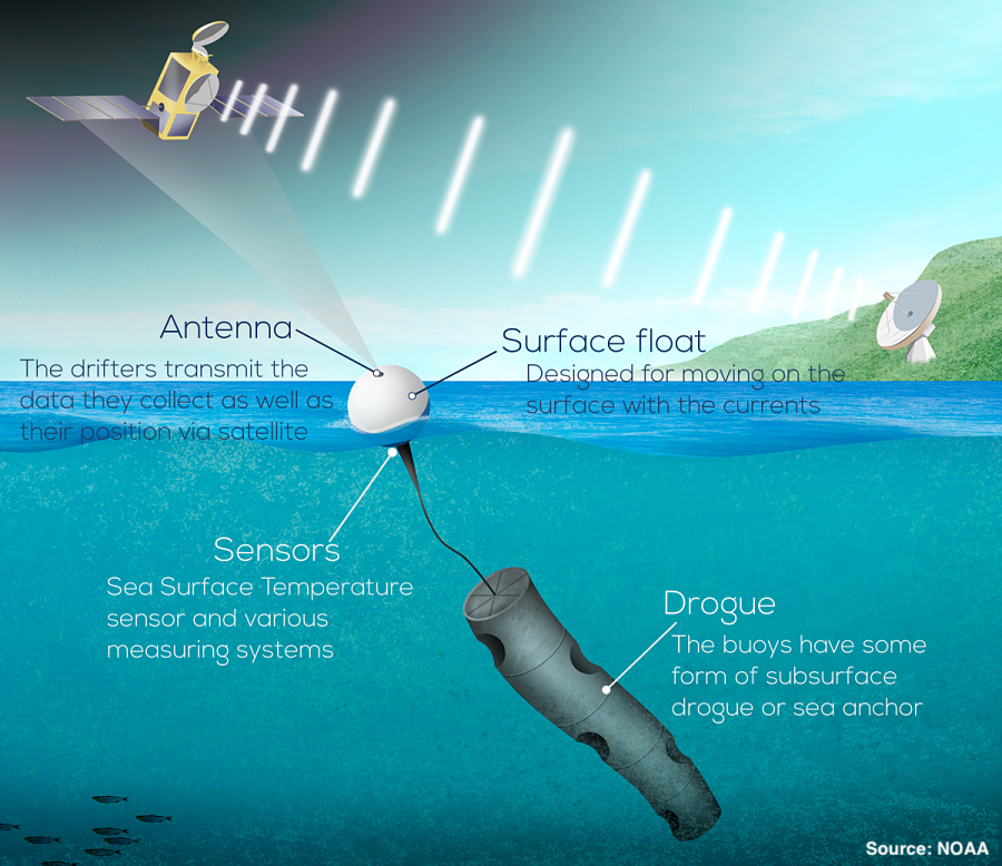
All drifters are equipped with a sea surface temperature sensor at the bottom of the surface float, which sits approximately 15cm below the ocean surface.
As long as the drogue remains attached, all drifters measure near-surface ocean current velocities. If the drogue is lost at sea, the wind and waves play a greater role in moving the drifter.
The drogue, also known as a sea anchor, extends approximately 20m deep and is designed to move with the near-surface ocean currents. Because the drogue and surface float are connected by a long tether, the surface float is therefore moving with the near-surface currents as well. Without the presence of a drogue, the surface float will also be transported by wind and waves, much as a ping pong ball or beach ball is pushed across the surface of a pool.
The GDP requires that drogues are made of cordura nylon with rip-stop, with specific dimensions, but the GDP does not require a specific color for their drogues. As a result, drogue manufacturers often use surplus cordura nylon material from other jobs, which may consist of fluorescent pink, neon green, or even camouflage.
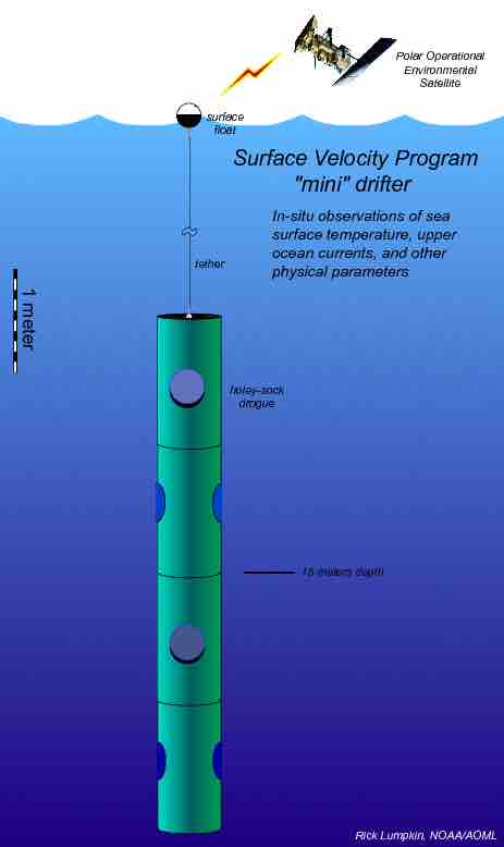
The surface float ranges from 30.5 cm to 40 cm in diameter, while the drogue diameter is approximately 61cm. Total weight (of surface float and drogue) is roughly 50 lbs. Compressed and packaged for shipping/deployment, drifters measure roughly 61cm x 61cm. However, once deployed, the drogue and tether unfurl, extending to roughly 20m beneath the ocean surface.
The surface float is made from form-injected ABS plastic. The surface float contains electronics that acquire and process sensor measurements, D-cell alkaline batteries to power the drifter, and an antenna to transmit the data. The tether is an impregnated polyurethane wire and the drogue is comprised of PVC tubing and nylon cloth material.
Drifters are powered by battery packs consisting of D-cell alkaline batteries, and are designed to last at least 18 months.
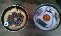
It takes a considerable amount of time to design the electronic components and computer programs necessary, yet with all materials on-hand, it takes approximately 1 week to assemble each drifter. Of course, manufacturers often build drifters in batches. Therefore, assembling components and testing a larger number of drifters at once increased production and minimizes the amount of time needed to shift from one procedure to another. While drifters are not assembled on a conveyor belt, imagine this process as an assembly line, as each drifter within the batch receives the same components before moving on to the next item on the production checklist.
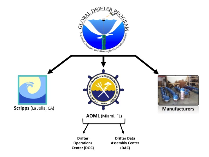
The Global Drifter Program is a part of the Global Ocean Observing System, which maintains a 5 x 5 degree array of ~1300 drifters. The program manages the collection, analysis, and distribution of the data acquired by these drifters.
The GDP is managed with close cooperation between:
Manufacturers in private industry, who build the drifters according to closely monitored specifications;
NOAA’s Atlantic Oceanographic and Meteorological Laboratory (AOML), which coordinates deployments, processes the data, archives the data, maintains metadata files describing each drifter within the program, develops and distributes data-based products, and maintains the GDP website; and
Scripps Institution of Oceanography (SIO), which supervises the industry, upgrades technology, and purchases most drifters.
Liaisons between the GDP and individual research programs that deploy drifters are maintained by Dr. Rick Lumpkin (AOML) and Dr. Luca Centurioni (SIO).
The primary goal of the GDP is to establish a global array of drifters with drifters present in each 5 x 5 degree grid of open ocean and to provide these data in near-real time for weather prediction and ocean state estimation. The Global Drifter Program is also tasked with providing quality controlled data for scientific use.
The GDP array reached its goal size of 1250 drifters in a 5 x 5 degree array on September 18, 2005 and has been maintained since. It was the first component of the Global Ocean Observing System to reach completion.
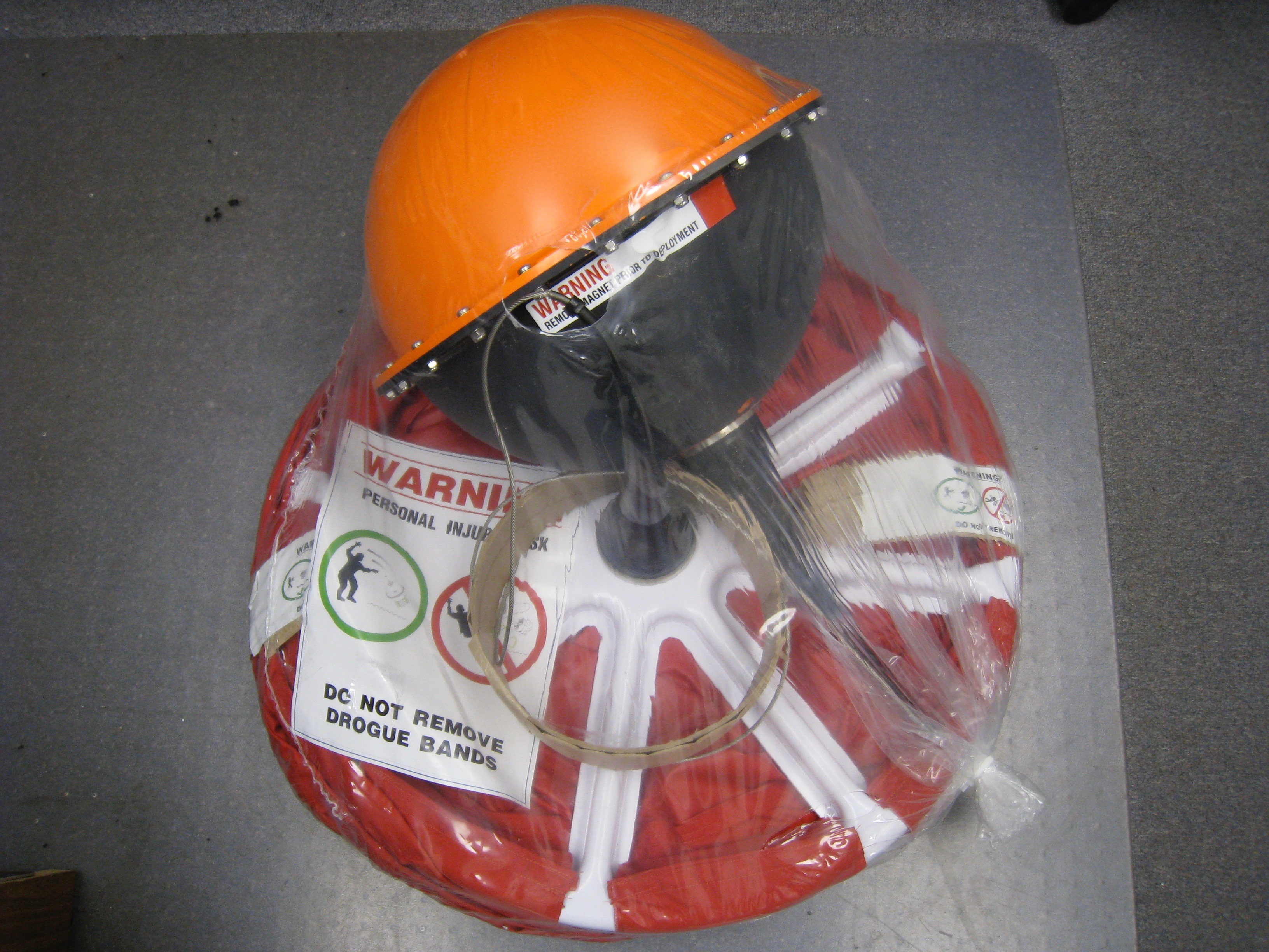
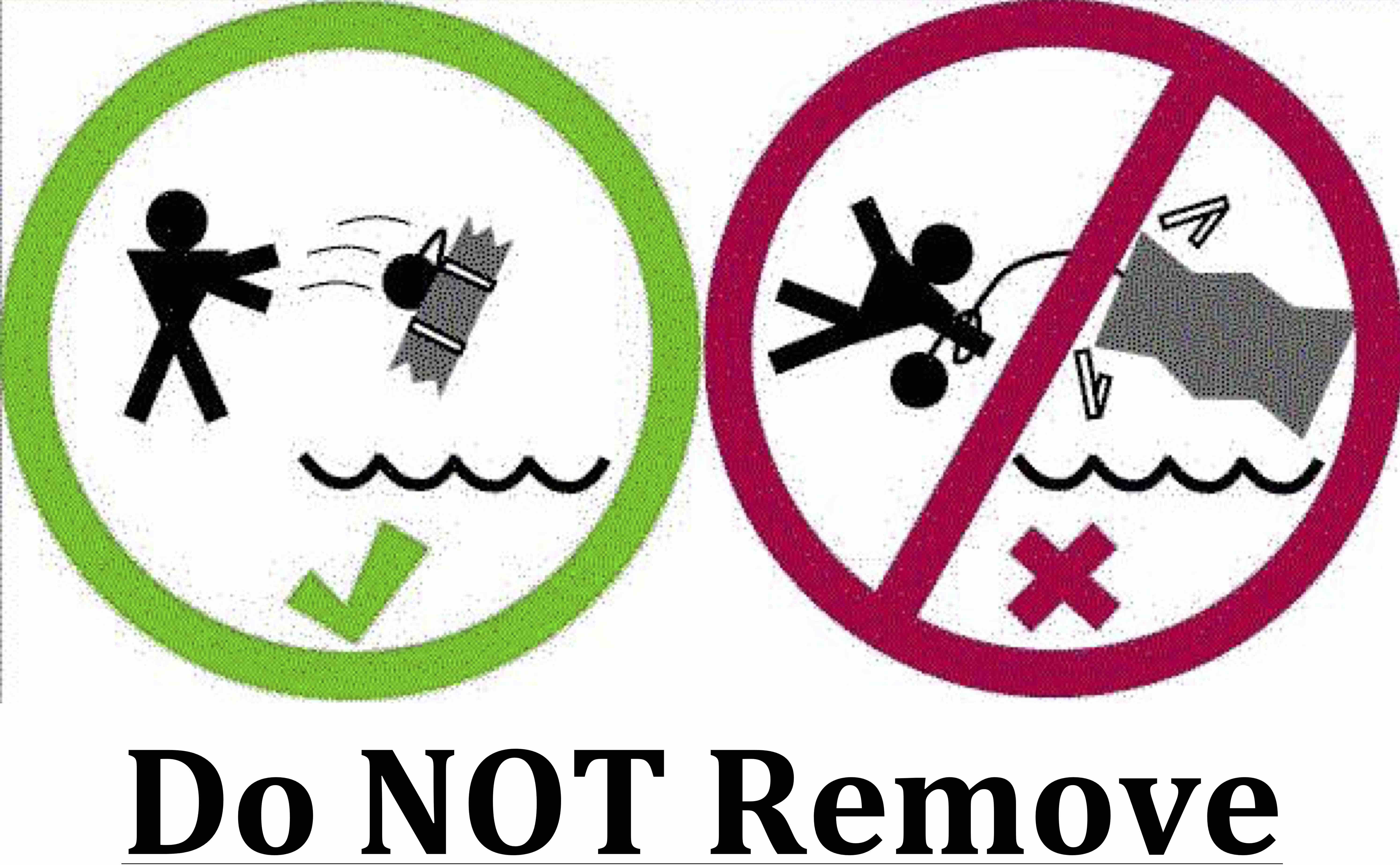
2) DO NOT REMOVE the paper tape securing the drogue and/or tether. Likewise, DO NOT REMOVE the carboard surrounding the float.
3) Record the ID/IMEI number listed on the drifter. This number can be found on the shipping container, the plastic shrink-wrap, or the protective cardboard box. It is also on the surface float itself.
4) Deploy the buoy from the stern, at the lowest possible deck (preferably less than 10 meters, including heave), into the sea. The ship may be traveling between 0 and 20 knots. The tether and drogue are secured with paper tape that will dissolve in the water.
5) Record the date, time (GMT), coordinates at deployment, and deployment details, then email this information to the Global Drifter Program.
Complete instructions, in multiple languages, can also be found at
aoml.noaa.gov/phod/gdp/deployment_instructions.
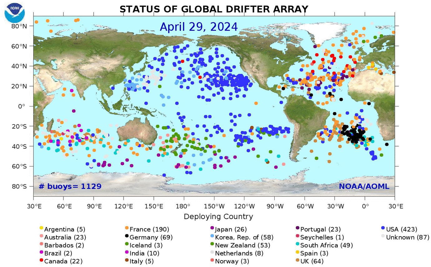
Drifters are deployed throughout the world’s open oceans. To view a map of the current drifter locations (updated weekly), please visit aoml.noaa.gov/phod/graphics/dacdata/globpop_countries.
Approximately 1000 drifters are deployed each year by the GDP and its international partners to maintain the global 5 x 5 degree array of ~1300 drifters. To view the number of deployments per year and their locations, please visit
aoml.noaa.gov/phod/gdp/maps_reports_archive.
The goal of the drifter program is to implement one drifter in each 5 x 5 degree grid across the globe. Of course, with strong convergent and divergent currents to contend with, as well as limited access to deployment vessels, the GDP works closely with more than fifty domestic and international agencies to coordinate deployment efforts. To maximize spatial drifter coverage and ensure its goals are met, the GDP created a set of Drifter Deployment Value Maps which are used throughout the community to identify the highest value deployment locations.
Primarily oceanographers, meteorologists, and climatologists deploy and utilize drifter data. However, because drifter data can be used to track oil spills, marine debris, larval fish dispersion, etc. there is a growing list of deploying partners and data consumers.
Oceanographic and climate researchers analyze the data to find aspects of the data that can be applied to other observations or explain phenomena.
In an effort to better educate K-12 students about the importance of the ocean and how drifters provide invaluable data, the GDP works closely with NOAA’s Adopt a Drifter Program. Through the Adopt a Drifter Program, the GDP teaches young scientists how to access drifter data and its many applications.
- Primarily oceanographers, meteorologists, and climatologists deploy and utilize drifter data. However, because drifter data can be used to track oil spills, marine debris, larval fish dispersion, etc. there is a growing list of deploying partners and data consumers.
- Oceanographic and climate researchers analyze the data to find aspects of the data that can be applied to other observations or explain phenomena.
- In an effort to better educate K-12 students about the importance of the ocean and how drifters provide invaluable data, the GDP works closely with NOAA’s Adopt a Drifter Program. Through the Adopt a Drifter Program, the GDP encourages young scientists how to access drifter data and its many applications.
While possible to increase/decrease the time interval between data transmissions, the standard transmission rate for drifting buoys is one transmission per hour, at the top of each hour. A fix is when a satellite receives a particular transmission and relays it to a land-based data center.
Kriging is an optimum interpolation procedure which is commonly used for two and three-dimensional analyses. It is the method used at the drifter Data Assembly Center to interpolate (fill in the gaps in the data) and make them equally spaced into six hour intervals.
See Hansen, D.V. and Poulain, P.M., 1996, [PDF] for a complete description of the quality controlled and interpolation procedures applied to the drifter data in this database.
WMLE is an optimized model for the most likely location of a drifter given an estimate and a known error range. It is the method used at the drifter Data Assembly Center to interpolate (fill in the gaps in the data) and make them equally spaced into hourly intervals.
For more information, see Elipot et al. (2016) [PDF].
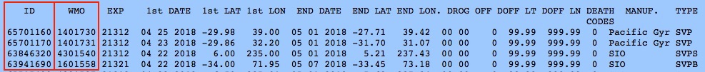
Drifter ID numbers are preprogrammed into each transmitter. Thus, each drifter is identified by the transmitter inside, as the ID number is sent as a “signature” within each data message received. With nearly 1300 drifters transmitting every hour, it is essential to differentiate messages and separate them accordingly. The WMO number is assigned after the deployment region is identified. This number is the seven digit number used to reference data placed onto the Global Telecommunication System (GTS), for public distribution and archiving.
WMO numbers are assigned after the deployment region is identified. WMO numbers are seven digit numbers used to reference data placed onto the Global Telecommunication System (GTS), for public distribution and archive. The first two digits of the WMO number correspond to the deployment region, which can be found on the map below.
WMO numbers can be found in two places.
- If you already know the ID number of your particular drifter(s), please utilize the table found at:
aoml.noaa.gov/phod/dac/wmoid. - To find drifters within a specific region, or timeframe, please reference the GDP Directory File, at:
aoml.noaa.gov/phod/dac/dirall.
- The WMO number is shown in the second column, immediately to the right of the corresponding ID number. A sample of the Directory File can be found below.
Happily, the drifter data is FREE and accessible to the public, courtesy of NOAA’s Climate Program Office!
Drifter data are quality controlled and stored at AOML’s Drifter Data Assembly Center, then sent to Canada’s Marine Environmental Data Service for archiving and public distribution.
For links and instructions to access real-time drifter data, please visit
aoml.noaa.gov/phod/gdp/real-time_data
For quality controlled interpolated drifter data, please visit
aoml.noaa.gov/phod/gdp/interpolated/data/all.
Links and instructions to access real-time drifter data, can be found at aoml.noaa.gov/phod/gdp/real-time_data.
- To search for real-time drifter data by specific time and location, visit
aoml.noaa.gov/phod/gdp/real-time_data. - To search for interpolated data by specific time, location and/or ID #, visit
aoml.noaa.gov/phod/gdp/interpolated/data/all. - To download the entire hourly drifter dataset, visit
aoml.noaa.gov/phod/gdp/hourly_data.
The quality controlled drifter data is updated every 2-3 months. Therefore quality controlled drifter data is available delayed mode, with notifications of these updates found at aoml.noaa.gov/phod/gdp.
Quality controlled drifter data is available for download via the AOML GDP ERDDAP. For instructions how to use ERDDAP to download subsets of GDP data in common file formats, visit 6-Hour Interpolated Data Request Instructions or Hourly Interpolated Data Request Instructions.
Quality controlled drifter data can also be downloaded from ftp://ftp.aoml.noaa.gov/pub/phod/buoydata, using a secure FTP client, such as FileZilla.
Several files containing different kinds of metadata information are available on the web:
From the GDP Home page, select Global Drifter Program at the top of the screen, then navigate to Metadata. From there, you will find several options to choose from. Direct links are found below:
-
Drifter Deployment Information:
aoml.noaa.gov/phod/dac/deployed -
Quality Controlled Metadata:
aoml.noaa.gov/phod/dac/dirall -
Drifter Death Probabilities:
aoml.noaa.gov/phod/dac/drifter_deaths
Hardware metadata are available at:
-
Drifter Specifications:
aoml.noaa.gov/phod/dac/Drifter_Specifications -
Barometer Specifications:
aoml.noaa.gov/phod/dac/Barometer_Metadata -
Drogue Specifications:
aoml.noaa.gov/phod/dac/Drogue_Specifications
The Global Drifter Program was established in 1979. While it took several decades to develop the program and reach its current state, with roughly 31,200 transmissions per day, the first drifter to transmit data was deployed on February 14, 1979.
Determining drogue presence is vitally important, as this component of the drifter is what allows researchers to measure ocean current velocities at 15 meters depth. Without the drogue, which is centered at 15m, wind plays a greater roll in transporting drifters.
For this reason, AOML’s Data Assembly Center spends a tremendous amount of time and resources to pinpoint exactly when, and where, each drifter loses its drogue.
While sensor failures are identified and listed within the quality controlled dataset, you can determine real-time sensor functionality by uilizing the WMO number from a particular drifter and visiting meteo.shom.fr/qctools.
An example of a drifter that has lost its drogue is shown in the figure below. Notice, the amount of strain on the lower hull of the surface float decreases significantly after drogue loss. At the same time, the time to first fix (how long it takes to acquire a GPS location fix) decreases significantly because the drogue is no longer pulling the surface float underwater with each passing wave.

All drifters are equipped with a sea surface temperature sensor at the base of the surface float.
While sensor failures are identified and listed within the quality controlled dataset, you can determine real-time sensor functionality by uilizing the WMO number from a particular drifter and visiting meteo.shom.fr/qctools.
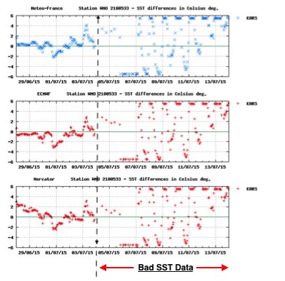
An example of a failed sea surface temperature sensor is shown in the figure below. Notice, the structured diurnal pattern becomes erratic and irregular on Aug. 4th, 2015.
While not all drifters are equipped with barometric pressure sensors, nearly half of the global drifter array measures sea-level pressure, which feeds into weather forecasting models.
While sensor failures are identified and listed within the quality controlled dataset, you can determine real-time sensor functionality by uilizing the WMO number from a particular drifter and visiting meteo.shom.fr/qctools.
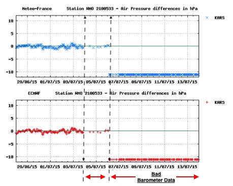
An example of a failed pressure sensor is shown in the figure below. Notice, the slight pressure fluctuations begin on August 4th, 2015, then the sensor experiences complete failure on August 6th, 2015.
To minimize costs associated with global transport, drifters are shipped via ocean freight, on large container ships. Therefore, depending on the destination, shipments vary between a couple of weeks to four months for more remote and isolated regions of the world.
Drifters are not known to harm marine wildlife. Conversely, recovered drifters often contain crustaceans, which are known to attract larger species, creating a micro-habitat.
The longest lasting drifter on record transmitted for 10 years, 4 months, and 21 days.
If you find a drifting buoy, please Contact a member of the Global Drifter Program with any/all information listed on the surface float. If the drifter remains active, with functional batteries and operational sensors, we’ll attempt to have the drifter re-deployed. If the batteries and/or sensors are no longer operational, the drifter can be disposed. These drifters contain no hazardous material, so simply dispose of the drifter as you would any other alkaline battery product.
If you have general questions about drifters that were not covered within these FAQ’s, we encourage you to explore our Website for additional information and resources.
If you have specific questions about drifter deployments, please contact Shaun Dolk.
To contact another member of the GDP, please visit Contacts.